Lake Erie is the fourth-largest lake of the five Great Lakes in North America. It’s surface area is more than 9,990 square miles. It is the eleventh-largest lake on Earth if measured in terms of surface area. It is the southernmost, shallowest, and smallest by volume of the Great Lakes and therefore also has the shortest average water residence time. At its deepest point Lake Erie is 210 feet deep and sits at an elevation of 571 feet above sea level. It’s length is 241 miles and width of 57 miles at its widest point.
More than 30% of the total population of the Great Lakes basin is in the Lake Erie watershed. Approximately twelve million people live in the watershed, including seventeen metropolitan areas with more than 50,000 residents. The lake provides drinking water for about eleven million people.
Situated on the International Boundary between Canada and the United States, Lake Erie’s northern shore is the Canadian province of Ontario, specifically the Ontario Peninsula, with the U.S. states of Michigan, Ohio, Pennsylvania, and New York on its western, southern, and eastern shores. These jurisdictions divide the surface area of the lake with water boundaries. Major cities along Lake Erie include Buffalo, New York; Erie, Pennsylvania; Cleveland, Ohio, and Toledo, Ohio.
The lake was named by the Erie people, a Native American people who lived along its southern shore. The tribal name “erie” is a shortened form of the Iroquoian word erielhonan, meaning “long tail”.
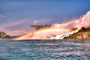
Lake Erie is mostly fed by the Detroit River and drains via the Niagara River and Niagara Falls into Lake Ontario. Navigation downstream is provided by the Welland Canal, part of the Saint Lawrence Seaway. Other major contributors to Lake Erie include the Grand River, the Huron River, the Maumee River, the Sandusky River, the Buffalo River, and the Cuyahoga River. The drainage basin covers 30,140 square miles.
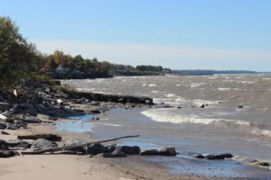
Over half of the United States shore of Lake Erie lies in Ohio, which, counting islands and Sandusky Bay, amounts to 312 miles. Generally, this shoreline has three facets. From the Michigan line eastward to Vermilion, the landscape is monotonously flat. Rich farmland occupies this former lakebed. Along the shoreline are marshes, usually separated from the lake by narrow barrier beaches. These marshes are of great importance to migrating waterfowl, but with two exceptions these are private lands of hunting clubs. The only break in the continuity of marshy shoreline is the Marblehead Peninsula and the so-called Catawba Island on the north side of Sandusky Bay. The Silurian limestone of this area is also characteristic of the islands of Lake Erie–the second region.
There are four main islands in American waters: Kelleys Island, South Bass, Middle Bass and North Bass Islands. Agriculture, fishing and tourism are their principal economic stays. An island vacation has great appeal, and state parks of sufficient size, stressing camping as a primary feature, could be expected to receive considerable visitation.
From the vicinity of Vermilion to the Pennsylvania line is the shore bluff sector. This segment of Lake Erie compares with the most heavily developed shores on the Great Lakes. A vast complex of marinas, private beaches, exclusive developments, and industrial operations crowd to the edge of the eroding bluffs. Since the natural scene has long been altered, since development is essentially complete, little possibility exists of obtaining natural frontage for public recreation along this section.
Of the five states with more than 100 miles of Great Lakes shoreline, Ohio probably has the greatest degree of lakeside development. There are no extensively forested lands fronting Erie’s shores. There are no long, untouched tracts of beach. Farmland, cottage and resort development, industrial frontage, highways and cities have long since appropriated the vast majority of the shoreline.
Lake Erie Fishing:
Lake Erie is home to one of the world’s largest freshwater commercial fisheries.
Lake Erie has the largest commercial fishery of any Great Lake, with most of the fish being harvested from Canadian waters. Yellow perch and walleye make up most of the Canadian commercial harvest, while those species dominate U.S. recreational and charter catches.
Thanks to its habitat diversity, Lake Erie supports more fish species than any other Great Lake. The Lake Erie basin supports several native and invasive fish species not found in other Great Lakes watersheds. The Sandusky River also has the dubious distinction of being the first known breeding habitat in the region for an Asian carp species; grass carp eggs were first collected there in 2015.
Lake Erie’s fish populations are the most abundant of the Great Lakes, partially because of the lake’s relatively mild temperatures and plentiful supply of plankton, which is the basic building block of the food chain. The lake’s fish population accounts for an estimated 50% of all fish inhabiting the Great Lakes. The lake is “loaded with superstars” such as steelhead, walleye/pickerel, smallmouth bass, perch, as well as bass, trout, salmon, whitefesh, smelt, and many others. The lake consists of a long list of well established introduced species. Common non-indigenous fish species include the rainbow smelt, alewife, white perch and common carp. Non-native sport fish such as rainbow trout and brown trout are stocked specifically for anglers to catch
The lake also supports a strong sport fishery. While commercial fishing declined, sport fishing has remained. The deep cool waters that spawn the best fishing is in the Canadian side of the lake. As a result, a fishing boat that crosses the international border triggers the security concerns of border crossings and fishermen are advised to have their passport. If their boat crosses the invisible border line in the lake, upon returning to the American shore, passengers will have to “drive to a local government reporting station and pose for pictures” to Customs officers by videophone. There are cumbersome rules for fishing boat operators as well, who will have to fax passenger personal information to a government agency an hour before leaving; officers will be watching and doing spot checks from patrol boats and government aircraft”.
Shipwreck Diving:
Lake Erie is a favorite for divers since there are many shipwrecks, perhaps 1,400 to 8,000 according to one estimate, of which about 270 are “confirmed shipwreck locations.” Most wrecks are undiscovered but believed to be well preserved and in good condition and at most only 200 feet (61 m) below the water surface. One report suggests there are more “wrecks per square mile” than any other freshwater location, including wrecks from Native American watercraft. There are efforts to identify shipwreck sites and survey the lake floor to map the location of underwater sites, possibly for further study or exploration.
While the lake is relatively warmer than the other Great Lakes, there is a thermocline, meaning that as a diver descends, the water temperature drops about 30 degrees Fahrenheit change, requiring a wet-suit. One estimate is that Lake Erie has a quarter of all 8,000 estimated shipwrecks in the Great Lakes. They are preserved because the water is cold and salt-free creating “intact time capsules down there”. Divers have a policy of not removing or touching anything at the wreck else the “next person won’t be able to see it”; when artifacts were removed on occasion, it was met by “outrage” by the diving community. The cold conditions make diving difficult and “strenuous” requiring divers with skill and experience. One charter firm from western New York State takes about 1,500 divers to Lake Erie shipwrecks in a typical season from April through October.
Parks At lake Erie:
There are numerous public parks around the lake. In western Pennsylvania, a wildlife reserve was established in 1991 in Springfield Township for hiking, fishing, cross-country skiing and walking along the beach. In Ontario, Long Point is a peninsula on the northwest shore near Port Rowan that extends 20 miles into Lake Erie which is a stopover for birds migrating as well as turtles; one reporter found a “turtle-crossing” sign along the road; Long Point Provincial Park is located there and has been designated as a UNESCO Biosphere reserve. In Ontario’s Sand Hill Park, east of Port Burwell, there is a high 450ft dune which is so steep it requires people to “crawl like crabs to the summit”, although there are lake views from the top.
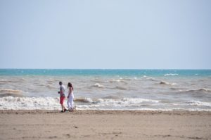
Crystal Beach, in the village of Crystal Beach, Ontario, at the eastern end of the lake, is one of several South-facing beaches on the Canadian side. It is therefore well situated for sun-bathers, facing the sun from sunrise to sunset. The beach is gently sloping with no sharp drop-offs or rip currents, and is usually cooled by southwest breezes, even on the hottest days.
In southern Michigan, Sterling State Park has campgrounds, 1,300 acres for hiking, biking, fishing, boating, with a sand beach for sunbathing, swimming, and picnicking.
Lake Erie Islands:
Kelleys Island has activities such as beach lounging, hiking, biking, and viewing the deep glacial grooves in the bedrock limestone.
Pelee Island is reached by ferry from Leamington, Ontario or by plane or ferry in Sandusky, Ohio and is the largest of the Lake Erie islands. The island has a unique ecosystem with plants rarely found in Canada such as wild hyacinth, yellow horse gentian, and prickly pear cactus. There are two endangered snakes including the blue racer and the Lake Erie water snake. Songbirds migrate there in spring, and monarch butterflies stop over during the fall.
South Bass Island has the island-village of Put-in-Bay, Ohio which attracts young crowds who sometimes are prone to general merriment. It has been described as a party island with scenic rocky cliffs with a year-round population in the hundreds that grows during summer.
Water Sports At lake Erie:
Kayaking has become more popular along the lake, particularly in places such as Put-in-Bay, Ohio. There are extensive views with steep cliffs with exotic wildlife and more than 100 miles of paddle-friendly shoreline. Long distance swimmers have swum across the lake to set records; for example, a 15-year-old amputee swam the 12 mile stretch across the lake in 2001. In 2008, 14-year-old Jade Scognamillo swam from New York’s Sturgeon Point to Ontario’s Crystal Beach and completed the 11.9-mile (19.2-km) swim in five hours, 40 minutes and 35 seconds, and also became the youngest swimmer to make the crossing. It is illegal for swimmers younger than 14 to attempt such a crossing. In Port Dover, Ontario, brave swimmers do high-dives at the annual Polar Bear Swim on the beach. Currents can sometimes pose a problem, and there have been occasional incidents of drownings so you have to be very careful about playing in the water.
Lighthouses At Lake Erie:
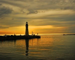
The lake is dotted by distinct lighthouses. A lighthouse off the coast of Cleveland, beset with cold lake winter spray, has an unusual artistic icy shape, although sometimes ice prevents the light from being seen by maritime vessels.
Vineyards
There are numerous vineyards around the lake, including ones on Pelee Island which makes wines including pinot noir, riesling and chardonnay.
Ferryboats At lake Erie:
Ferryboats operate in numerous places, such as the Jet Express Ferry from Sandusky and Port Clinton. However, plans to operate a ferryboat between the U.S. port of Erie and the Ontario port of Port Dover ran into a slew of political problems, including security restrictions on both sides as well as additional fees required to hire border inspectors. In particular, Canada was described as having a “sticky set of laws”; the project was abandoned.
The Great Lakes Circle Tour is a designated scenic road system connecting all of the Great Lakes and the St. Lawrence River. One reporter thought the roads on the Canadian side were narrower, sometimes without shoulders, but were less trafficked except for the roads around the Ontario towns of Fort Erie and Port Colborne. Drivers can cross from the United States to the Canadian town of Fort Erie by going over the Peace Bridge.
Fast Facts about Lake Erie:
- the smallest by volume
- the shallowest
- warms rapidly in the spring and summer
- frequently freezes over in winter
- average depth is only about 62 ft. (19m)
- the western basin (about 20% of the lake), is very shallow with an average depth of 24 ft. (7.4m)
- retention time = 2.6 years (a measure based on the volume of water in the lake and the mean rate of outflow)
- most of the land area around the lake is urban or agricultural
- 17 metropolitan areas with populations over 50,000 within the Lake Erie basin
Superb blog about lake erie!