Lake Huron is the third largest of the Great Lakes by volume with 850 cubic miles of water. Its average depth is 195 feet and its maximum depth is 750. It also has a shoreline of more than 3,827 miles. It is shared on the north and east by the Canadian province of Ontario and on the south and west by the state of Michigan in the United States.
Lake Huron’s drainage area, which covers parts of Michigan and Ontario, is relatively large compared to the other Great Lakes. It’s more than twice the size of Huron’s approximately 23,000 square miles of surface water. The Saginaw River basin is intensively farmed and contains the Flint and Saginaw-Bay City metropolitan areas. Lake Huron is hydrologically inseparable from Lake Michigan, joined by the wide Straits of Mackinac.
Lake Huron’s name was given by early French explorers who named it for the Huron people inhabiting the region. The northern parts of the lake include the North Channel and Georgian Bay. Across the lake to the southwest is Saginaw Bay. The main inlet is the St. Mary’s River, and the main outlet is the St. Clair River.
Lake Huron can also be identified as the Great Lake that forms Michigan’s mitten shape right next to Canada. It has the longest shoreline of the Great Lakes. The Saginaw River basin is intensively farmed and contains the Flint and Saginaw-Bay City metropolitan areas. Saginaw Bay, like Green Bay, contains a very productive fishery.
In northern Lake Huron, features such as the North Channel, lower St. Marys River, and Les Cheneaux Islands provide varied habitats ranging from deep, cold channels to shallow, vegetated bays. These areas and high-quality tributary streams provide spawning and nursery habitat for many native and introduced fish species.
Fishing:
Farther south, Saginaw Bay is shallow, warm, and nutrient-rich compared to the lake’s main basin. Saginaw Bay tributaries include the Saginaw, Tittabawassee, and Flint rivers. Although these rivers have a history of industrial and agricultural pollution, they provide spawning habitat for important fish species such as walleye.
Lake Huron now offers quality mixed-bag fisheries in addition to offshore lake trout fishing. In the northern part of the lake, it is possible to catch Atlantic salmon, lake trout, rainbow trout, chinook salmon, coho salmon, pink salmon, and walleye on the same trip. Some nearshore areas also provide good fishing for northern pike, yellow perch, smallmouth bass, and cisco.
Lake Huron’s commercial fisheries include lake whitefish trap net fisheries in addition to multi-species fishing operations in Saginaw Bay and Canadian waters. Bloater “chubs” are also targeted with gill nets set in deep water.
Recreational fishing is a major economic driver for small Lake Huron communities. Many businesses struggled as chinook salmon numbers dropped during recent decades; meanwhile, others benefited from resurging native Saginaw Bay walleye populations. Saginaw Bay’s fisheries — particularly perch and walleye — represent more than 75 percent of Lake Huron’s total fishing participation. Commercial fishing and aquaculture are prevalent in Canadian waters of Lake Huron.
Shipwrecks on Lake Huron:
Throughout history more than a thousand shipwrecks have been recorded in Lake Huron. These wrecks include the first European vessel to sail the Great Lakes named Le Griffon which was built in 1679 on the eastern shore of Lake Erie, near Buffalo, New York. Robert Cavalier, Sieur de la Salle navigated across Lake Erie, up the Detroit River, Lake St. Clair and the St. Clair River out into Lake Huron. Passing the Straits of Mackinac, La Salle and Le Griffon made landfall on Washington Island, off the tip of the Door Peninsula on the Wisconsin side of Lake Michigan. Here, La Salle filled Le Griffon with pelts and in late November 1679 sent Le Griffon back to the site of modern-day Buffalo, but was not to be seen again.
Two wrecks have been identified as Le Griffon, although neither has gained final verification as the actual wreck. Blown by a fierce storm after leaving, Le Griffon ran aground before the storm. The people of Manitoulin Island say that the wreck in Mississagi Straits at the western tip of the island is that of Le Griffon. Meanwhile, others near Tobermory, say that the wreck on Russell Island, 150 miles farther east in Georgian Bay is that of Le Griffon. A classic car was discovered inside the submerged shipwreck in November 2018.
Thunder Bay
Thunder Bay National Marine Sanctuary and Underwater Preserve covers about 448 square miles and contains 116 historically significant shipwrecks. It is the 13th National Marine Sanctuary designated by the National Oceanic and Atmospheric Administration (NOAA) which was established in 2000. Glass bottom boat tours can be taken from Alpena, Michigan, providing tourists with spectacular views of some of the famous shipwrecks within Thunder Bay.
Saginaw Bay
Within the waters of Saginaw Bay contains 185 sunken vessles . Matoa, a propeller freighter weighing 2,311 gross tons, was built in Cleveland in 1890, and was wrecked in 1913 on Port Austin Reef.
Georgian Bay, North Channel
Georgian Bay, the largest bay on Lake Huron, contains 212 sunken vessels in the lake.
Another historically interesting shipwreck is the Manola. It was a propeller freighter of 2,325 gross tons, which was built in 1890 by the Globe Shipping Company of Cleveland, Ohio. The ship became stranded on November 20, 1924, on Christian Island in Georgian Bay. Headed for Port McNichol, Ontario, it was declared a total loss after two weeks. Salvaging crews were able to recover approximately 75,000 bushels of barley for delivery to Midland, Ontario.
The Saginaw Bay region contains the largest populations and the geographically largest watershed, which feeds the Saginaw River and Bay. This region’s urban and rural landscapes are dominated by agriculture and industry. Michigan’s southern “thumb” region is mostly rural with population centers in Port Huron in the U.S. and Sarnia in Canada, at Lake Huron’s southernmost point. Other major population centers along the Lake Huron coastline include Alpena and Bay City in the U.S. and Owen Sound in Canada.
Past forestry, mining, agriculture, and industrial activities have contributed to Lake Huron’s ongoing water quality and contamination problems, particularly in the Saginaw River and Bay. Dams providing hydroelectric power also restrict fish passage on major tributaries such as the Cheboygan, Thunder Bay, and Au Sable rivers.
Fast Facts about Lake Huron:
- the second largest by surface area
- the third largest by volume
- Mackinac Island is a popular toursit attraction
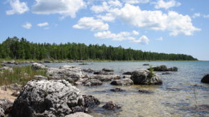
- vacation homes on the shallow, sandy beaches of Huron and along the rocky shores of Georgian Bay
- Saginaw River basin is intensively farmed
- Flint and Saginaw-Bay City metropolitan areas
- Saginaw Bay contains a very productive fishery